| DEAL ISLAND WEATHER |
| Web Counters | ||||||
|
|
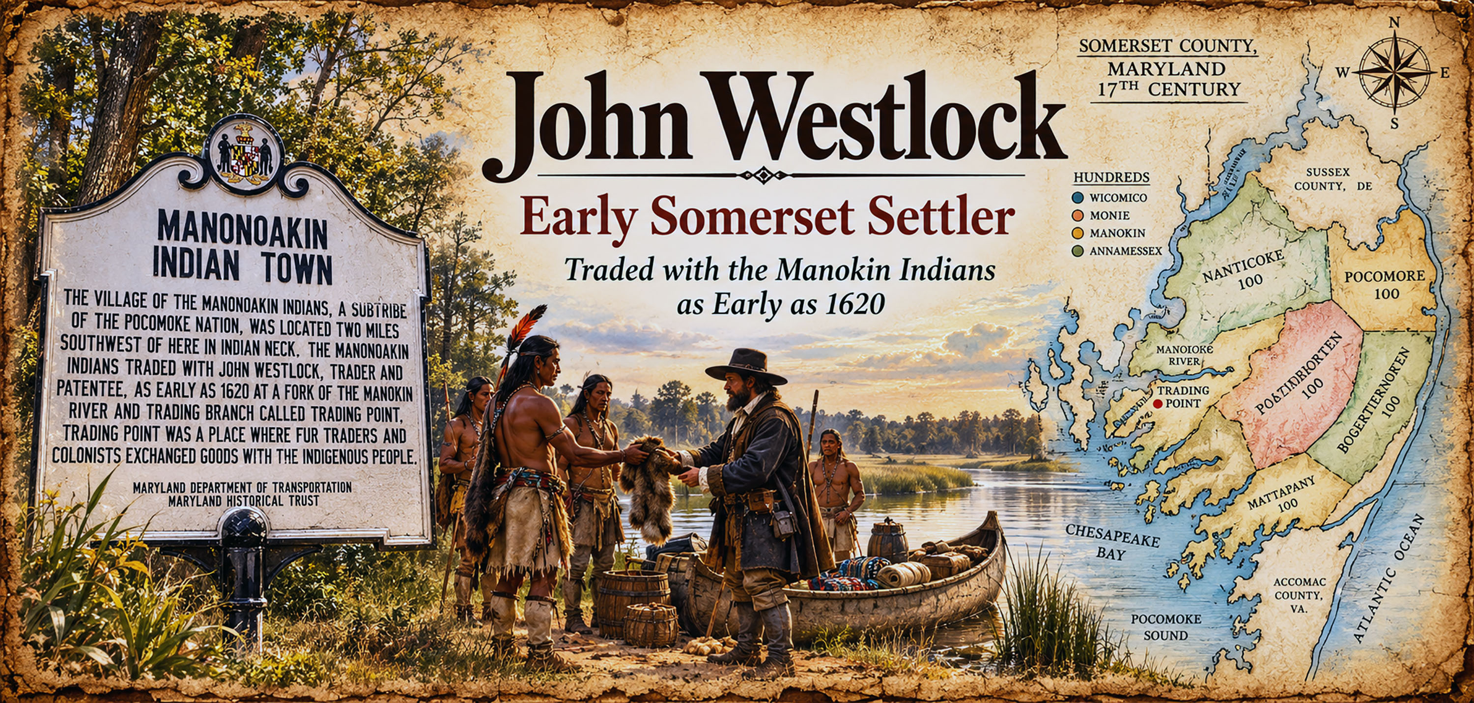
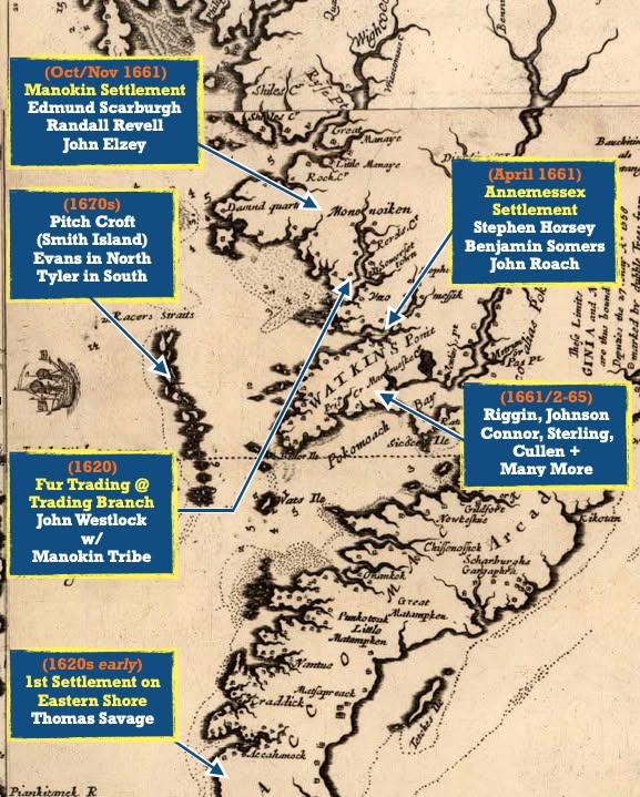
Thirteen years after the settlement of Jamestown in 1607, much of the land surrounding the Chesapeake Bay was still wilderness to Europeans. Only a year earlier, in 1619, a settlement had been established near present-day Cape Charles, Virginia, partly for the purpose of producing salt from seawater. It was among the earliest English settlements on Virginia’s Eastern Shore. The lower Eastern Shore of Virginia offered an attractive area for expanding English settlement. The Native peoples of that region, including the Accomack and Accohannock, generally maintained more peaceful relations with the English during this period than some tribes farther north. Beyond them lived other Native nations and communities, including the Pocomoke and Nanticoke peoples on the Eastern Shore and the Susquehannock farther north. In 1620, tobacco had not yet developed into the dominant cash crop it would soon become, and the fur trade remained an important part of Virginia’s economy. That commerce depended heavily upon trade with Native peoples. Trading relationships had already been established with Powhatan communities around Jamestown, but some of the more ambitious English colonists began venturing farther into the Chesapeake wilderness in search of additional trading opportunities. Such ventures were not without considerable danger. Relations between the English and Native peoples had already been marked by periods of serious conflict. Between 1610 and 1614, the First Anglo-Powhatan War was fought around Jamestown. English military campaigns during that conflict could be extremely harsh, including the destruction of Native villages, crops, and food supplies. Although a period of relative peace followed, relations remained uncertain and could change quickly. For an English trader to sail into largely unfamiliar territory and attempt to establish peaceful commerce with Native communities required courage, patience, and considerable preparation. A trader would need a suitable sailing vessel, merchandise for exchange, provisions, weapons and ammunition for hunting and protection, and ideally a guide or interpreter familiar with the people and waterways of the region. Perhaps most important, successful trade depended upon establishing trust. Patience, honesty, diplomacy, and personal integrity could mean the difference between profitable commerce and disaster. There are references to English trading activity along Virginia’s Rappahannock River by 1620. On the Eastern Shore, however, most documented English activity remained concentrated in the lower Virginia counties. Evidence suggests that trading may also have begun that year in the territory that would later become Somerset County, Maryland. Our most important reference comes from the Somerset County Court Records. In 1670, a man named John Westlock testified that he had begun doing business at a place called “Trading Branch” approximately fifty years earlier. If his recollection was accurate, that would place his activities there around 1620. His testimony appears not to have been challenged during the court proceeding, and I have found no surviving evidence that clearly contradicts his statement. Until stronger evidence is discovered, Westlock’s testimony provides an intriguing indication that English trade with Native people may have been taking place in what later became Somerset County as early as 1620. “Trading Branch” was located along the Manokin River near its junction with King’s Creek. The area can still be viewed today from the vicinity of Stewarts Neck Road near Princess Anne, Maryland. The Manokin River, and later the Manokin settlement established during the early 1660s, took their name from the Native
people who lived in that region. Likewise, the Annemessex River and the Annemessex settlement farther south preserved the name of the Annemessex people. Both Manokin and Manonoakin are historically defensible, but they are best used in slightly different ways. Manonoakin is the older place/tribal-name form seen on the historical marker and in some early records, while Manoakin and later Manokin appear as spelling variants in colonial records and eventually became the familiar modern spelling associated with the Manokin River. Seventeenth-century spelling was not standardized, so clerks often recorded the same Indigenous name several different ways. Colonial Maryland records describe the Manokin and Annemessex peoples as being associated with, or “belonging” to, the larger Pocomoke political community. Together, these Native communities occupied portions of the country surrounding Pocomoke Sound and the lower Tangier Sound long before permanent European settlement reached the region. Much more can be said about these early encounters, the Native communities who lived here, and the Europeans who gradually entered their homeland. ................the 400th anniversary of the earliest presently known evidence of European trade and contact with Native Americans in the Somerset County region — circa 1620. Four centuries later, the Manokin River still flows past the place remembered in the colonial records as Trading Branch, preserving a geographical link to one of the earliest chapters in the recorded history of Somerset County.
Manokin or ManonoakinThe Manokin Indians were a band or sub-tribe associated with the Pocomoke Paramountcy. They lived in an area known to the Native people as Arrococo, a neck of land later called Revell’s Neck. This area can generally be described as the land lying south of the Manokin River and north of Back Creek. A Manokin Indian town stood near a fork between the Manokin River and a southern branch known as Trading Branch. The stream was later called Mumford’s Branch and is known today as King’s Creek. This part of old Somerset County became an important meeting and trading place between Indigenous people of the Eastern Shore and some of the earliest European visitors to the region. Evidence preserved in the Somerset County Judicial Records indicates that English traders from the Virginia colony were visiting the Manokin River decades before Somerset County was established and before permanent English settlement had spread throughout this part of Maryland.³² Depositions given by early residents, traders, and visitors provide a remarkable picture of activity along the Manokin River watershed. One of the earliest accounts comes from "John Westlock," who stated that he had been trading with the Native people at Manokin as early as 1620. In 1666, Westlock received a patent from the Calvert proprietors for a tract called Brownstone, situated on the north side of the Manokin River, near the area of Trading Branch. Additional testimony survives from a land dispute involving Randall Revell and Richard Ackworth. In the trespass case, the Provincial Court at St. Mary’s ordered the Commissioners of Somerset County to summon local residents who could testify concerning the boundaries of Revell’s tract known as Double Purchase. German Gillett testified that in 1656 he traveled from the Rappahannock River in Virginia to trade in the Manoakin. He was accompanied by William Cooke, who served as his interpreter. According to Gillett, after traveling approximately two miles up the river, Cooke left him aboard the sloop and proceeded on foot to the Indian town to obtain permission for them to continue to Trading Branch. Two days later, an Indian returned to Gillett and guided him farther upriver to Trading Branch, which he described as the second branch on the south side of the river. Richard Burdick also identified Trading Branch as the second branch on the south side of the Manoakin River above the courthouse. He recalled a large stump standing in the middle of the branch and a row of stakes marking the remains of what had once been an Indian bridge. Burdick further stated that this was the place where Mr. Cooke and several others had traded with the Indians. Henry Hooper testified that in 1656 he encountered an Indian in the Sound while traveling aboard a vessel from the Rappahannock in Virginia to trade for corn. Hooper stated that they entered the Manoakin River, traveled to the Indian town, and continued to the fork known as Trading Branch. Nicholas Fountaine testified that he accompanied Mr. Elzey and Colonel Edmund Scarburgh to Raccoon Point. Using a compass, they surveyed upriver to Trading Branch, which was identified as the northern boundary of the tract called Double Purchase. Another witness, Christopher Nutter, stated that he had heard the Indians say that the point of land where Randall Revell lived had formerly been used as a place of trade.³³ Together, these depositions show that the Manokin River was an established place of contact and commerce between Native people and English traders by the middle of the seventeenth century—and possibly considerably earlier. Traders coming from Virginia traveled into the river seeking corn, furs, and other goods, while interpreters and local Native guides helped regulate access to the Indian town and trading places. The Manokin Indians apparently remained in the area for some time after the formation of Somerset County. In 1706, George Phoebus gave a deposition in Somerset County Court concerning the boundaries of land on Goose Creek belonging to Elzey and McClemmy. In his testimony, Phoebus recalled seeing Indian sweat houses and Indian cabins on the north side of Goose Creek, near the first gut entering from the river.³⁴ These surviving court records provide valuable evidence that the Manokin River was not simply a later English settlement area, but an important Indigenous homeland and trading center long before Somerset County came into existence. The references to an Indian town, bridge, cabins, sweat houses, interpreters, and established trading places offer rare glimpses into the interaction between the Manokin people and some of the earliest Europeans to enter this part of Maryland’s Eastern Shore. |